
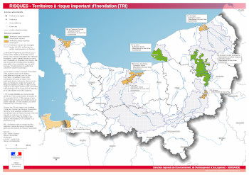
Les Territoires à Risque Important d'Inondation (TRI) en Normandie
Carte répertoriant les Territoires à Risque Important d'Inondation (TRI) selon la Directive inondation ainsi que les périmètres d'action des stratégies locales (SLGRI).
|
|
Proposition de citation
(2019) . Les Territoires à Risque Important d'Inondation (TRI) en Normandie. http://metadata.carmencarto.fr/geonetwork/8/api/records/5dfd0a5f-f7ef-4b7d-a0ce-b9da519f07da |
Simple
- Date ( Publication )
- 2019-06-25
- Forme de la présentation
- Carte numérique
Point de contact
- Mots clés ( Localisation )
-
- Normandie , Risques
- Mots clés ( Thème )
-
- données ouvertes
- Mots clés ( Thème )
-
- Atlas_DREAL
- Limitation d'utilisation
- Utilisation libre sous réserve de mentionner la source (a minima le nom du producteur) et la date de sa dernière mise à jour
- Contraintes d'accès
- Autres restrictions
- Contraintes d'utilisation
- Autres restrictions
- Autres contraintes
- Document sous licence libre Etalab
- Dénominateur de l'échelle
- 850000
- Langue
- Français
- Catégorie ISO
-
- Environnement
N
S
E
W
))
- Nom du système de référence
- Lambert 93
- Format (encodage)
-
- PDF (1.4 )
- Ressource en ligne
- Télécharger le fichier PDF
gmd:MD_Metadata
- Identifiant de la fiche
- 5dfd0a5f-f7ef-4b7d-a0ce-b9da519f07da XML
- Langue
- Français
- Jeu de caractères
- Utf8
- Type de ressource
- Jeu de données
- Date des métadonnées
- 2023-06-02T13:47:50
- Nom du standard de métadonnées
- ISO 19115:2003/19139
- Version du standard de métadonnées
- 1.0
Point de contact
Aperçus
Fourni par

Mode d'affichage
5dfd0a5f-f7ef-4b7d-a0ce-b9da519f07da
Lien vers le portal
Read here the full details and access to the data.
Ressources associées
Not available