
Atlas 2016 - Plans de prévention des risques naturels en Normandie : état d'avancement au 1er janvier 2016
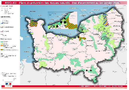
Carte répertoriant les Plans de prévention des risques naturels (PPRn) au 1er janvier 2016 par type (inondation, submersion marine, mouvement de terrain, multirisque, littoral) et suivant leur état d'avancement. Les territoires à risque important d'inondation sont aussi représentés.
|
|
Citation proposal
(2016) . Atlas 2016 - Plans de prévention des risques naturels en Normandie : état d'avancement au 1er janvier 2016. http://metadata.carmencarto.fr/geonetwork/8/api/records/6c2edf19-d93d-47b6-8121-360c357c4626 |
Simple
- Date ( Publication )
- 2016-06-03T00:00:00
- Date ( Revision )
- Date ( Creation )
- Presentation form
- Digital map
Point of contact
- Keywords ( Place )
-
- Normandie
- Keywords ( Theme )
-
- Données ouvertes , Atlas 2016 , Risques
- Use limitation
- Utilisation libre sous réserve de mentionner la source (a minima le nom du producteur) et la date de sa dernière mise à jour
- Access constraints
- Other restrictions
- Use constraints
- Other restrictions
- Other constraints
- Document sous licence libre Etalab
- Denominator
- 850000
- Metadata language
- French
- Topic category
-
- Environment
N
S
E
W
))
- Reference system identifier
- Lambert 93
- Distribution format
-
- PDF (1.4 )
- OnLine resource
- Télécharger le fichier PDF
gmd:MD_Metadata
- File identifier
- 6c2edf19-d93d-47b6-8121-360c357c4626 XML
- Metadata language
- French
- Character set
- UTF8
- Hierarchy level
- Dataset
- Date stamp
- 2023-06-02T13:48:17
- Metadata standard name
- ISO 19115:2003/19139
- Metadata standard version
- 1.0
Point of contact
Overviews
large_thumbnail
Provided by

Views
6c2edf19-d93d-47b6-8121-360c357c4626
Access to the portal
Read here the full details and access to the data.
Associated resources
Not available